Land referencing: what an acquiring authority should know?
The third of in a series of articles by the aspireCP team, looking at best practice in compulsory purchase from an acquiring authority’s perspective

Introduction
aspireCP specialise in supporting acquiring authorities to manage the risks associated with delivering compulsory purchase projects. Whilst we are not a land referencing company, we have decades of experience in procuring and managing land referencing for projects, ranging from the small scale to the largest and most complex. We have seen some excellent work and some not so good, but the common thread in delivering the best work is for those commissioning it to be clear about what they want and why. This article explores some of the practical issues acquiring authorities and project promoters can expect when procuring and managing land referencing consultants.
What is land referencing and why and when is it needed?
Land referencing is the process of ‘diligent inquiry’ to identify people or organisations (parties) that have a legal or equitable interest in the land or property that may be affected by a project and identifying the nature of that interest. Interests to be considered are those required for the project itself and, also those interests that, whilst not directly required for the project, may have a claim for injurious affection.
An acquiring authority has a legal obligation to consult with all parties identified as having a qualifying interest in land when an application is made for compulsory purchase powers. The Land Referencing process allows the acquiring authority to complete this consultation with confidence, ensuring all interests have been considered and that up to date contact information is available.The referencing team may also be engaged to support the wider project team in providing land ownership data to facilitate access to land and as well as in managing the prescribed service of notices or general communication with affected parties as the project matures.
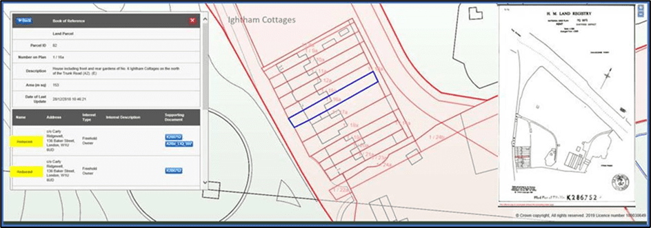
The primary source of land referencing data is the Land Registry. However, not all interests are registerable. Referencing data is pulled together from multiple sources, some publicly available some collected by direct contact with interested parties. It is presented as a ‘Schedule of Interests’ or ‘Book of Reference’ together with accompanying Plans. It is common to undertake land referencing early in the CPO process to understand the scale and issues with land acquisition and thereby inform a strategy for acquiring land by agreement. The same data will need to be refreshed and used again during the application for compulsory acquisition powers and also when the compulsory purchase powers have been confirmed and are about to be exercised through service of the GVD, Notice to Treat, notice of entry or temporary notice.
What data is required & in what format?
- Land/Property Type: agricultural, commercial, industrial or residential;
- Geographical Location – local authority/region;
- Situation – relationship to the surrounding interests/accessibility;
- Interest Type: Freehold, Leasehold, Copyhold, Tenancy, Occupation;
- Interest Type: Option Agreement, private rights, restrictions, and covenants;
- Powers sought over each parcel: Permanent, temporary, subsoil, rights.
Whilst historically a paper-based activity, technological innovation and the increasing availability of data in digital formats has moved land referencing firmly into the digital world. Taking advantage of increasingly sophisticated GIS and relational database functionality allows the referencing team to capture, manage and present land interest data more efficiently. Managing referencing data digitally also allows acquiring authorities to respond to project design and land requirement changes quickly, whilst maintaining an audit trial for all data affected. Production of deliverables is quicker and more cost effective allowing efficient version control and exchange of data across the wider project team giving, greater visibility of underlying data and prompting informed decision making.
Procurement
There are perhaps a handful of major land referencing companies providing services in this market, together with a number of smaller firms. The methodology, data structure, quality of geo-spatial systems employed and their focus on quality assurance all vary widely. This will be an issue if you employ multiple land referencing suppliers, change suppliers or want to import electronic land referencing data for use in another database such as a stakeholder management and want to use addressed for mailshots.

An experienced compulsory purchase solicitor should be able to advise on who is best suited for your project and the key data requirements of the CPO application. However, the CPO surveyors will be using the data to value compensation assessments and they can also advise on how data can be most usefully structured and on the extent of land to be included. For example, to assess the compensation estimate for severance[1] the valuer will need to know the extent of the hereditament which will extend beyond the boundary of land parcels to be acquired.
It is therefore essential for acquiring authorities to provide a comprehensive brief. Establishing and clearly communicating a legal and technical specification of the referencing requirements at the outset, supported by a robust change control process will ensure the referencing data produced is fit for purpose and meets the needs of all project stakeholders. Best value is then a balance between quality, cost and risk. Experience suggests that you get what you pay for and if in doubt, clients should aim for quality as this is likely to save cost in the long run.
What is the land referencing process?
All land enquiry activities should be completed in accordance with the timetable agreed with the acquiring authority and other key stakeholders. The process begins with:
- Non-Contact Research/Enquiries. This is initial interrogation of publicly available datasets and typically includes the preparation and submission of a Search of Index Map (SIM) to HM Land Registry or an equivalent search of National Polygon Service (NPS) data to identify those registered titles falling with an agreed search area or Area to be Referenced (AtbR) limits. Additional search requests submitted at this stage may include enquiries to relevant Local Authority departments responsible for e.g. Planning, Highway and Property Local Charges data across the AtbR. Title Analysis will reveal parties identified as having an interest in land within or affecting the AtbR and any contact details that existed at the time of registration. Such details may no longer be current and the referencing team will seek to confirm or update these details utilising sources such as Council Tax/Business Rate records, Companies House data, Electoral Roll records, Royal Mail address files. Evidence obtained at this stage will be filed along with the original contact data to provide an audit trial as to the provenance of current entries. Where amended contact details are revealed or where no confirmation of existing contact details is possible, such records will be flagged for further review and research. Research into parties’ addresses is aimed at producing a set of contact details for the acquiring authority to use, first to communicate with each party during the project and subsequently to serve legal notices. Best practice is to capture data into a spatially enabled, relational database facilitating ongoing update, enquiry, and maintenance. Capture should be completed as part of a robust Quality Control regime within an auditable Quality Assurance process.

- Contact Enquiries. At an agreed point in the project, the referencing team will initiate contact with all parties to seek confirmation of details garnered and to investigate other, unregistered, informal interests known to the parties. Such enquiries are generally conducted by issuing Requests for Information in the form of Land Interest Questionnaires (LIQ). LIQs are designed to encourage the recipient to provide full details of their interests. The use of acquiring authority powers to require parties to respond to such enquiries should be included in the agreed requirements specification, allowing explanatory notes and extracts of appropriate legislation to be included in the LIQ pack. Traditionally LIQ packs would be sent and responded to as paper documents, but it has been found that providing an additional on-line response option for such enquiries encourages a higher level of response. Receipt of responses from LIQs will reveal information that confirms, updates or conflicts with data already held. A parallel activity to the use of LIQs will be the completion of follow up enquiries in the form of direct contact with the individual parties to provide clarification or confirmation. It is imperative that all such contact events are recorded and filed along with other research evidence, cross linked to parties and interests to which they relate. Alongside the logging of party, address and interest data, the referencing team will be creating draft land parcel extents to facilitate the presentation of interests and party information. Land parcel extents will initially be based on the ownership details emerging from research. Once draft parcel boundaries are completed, cross-checking of these boundaries against existing detail on site will progress as a series of site visits. The site visits also allow the team to confirm descriptions of the land/property affected, to identify any third-party occupational interests not previously identified and allow face to face contact with occupiers providing a further opportunity to confirm information previously identified.
- Confirmation Activities. As the project nears the date for submission of land interest data, it may be prudent to complete a confirmation exercise with affected parties. This is completed by presenting each party with a schedule containing details of all relevant interests held against that party affected by the project. Parties are then invited to confirm completeness/accuracy of such records and return this to the referencing team.
- Preparation of Deliverables. Land interest data will be presented as a schedule of interests/ Book of Refence using uniquely numbered parcel records in a pre-defined format. Alongside these schedules a pre-defined set of plans indicating the position of all parcels contained.
What are the risks?

The referencing team must be able to supply appropriate proof of interest and supporting documentation in a timely manner to mitigate the impact of any challenge to data accuracy. The ability to supply such evidence is reliant on there being a comprehensive and auditable data store of all documentation and communications completed as part of the referencing activities. Whilst sources such as Land Registry, Local Authorities, Rural Payments Agency and Statutory Undertakers all make data available online, the Referencing Team must understand the provenance, accuracy and limitations of such data. Completing supplementary research or cross-referencing from multiple sources will help confirm the suitability of each accessed database for the use to which it is put.
Due to shortcomings in the historical registration of land interests in the UK and ongoing informal arrangements dealing with occupation of land, it is possible that unknown owners of interests in land may remain in the final data. To mitigate the risk of challenge, the Referencing team should agree with the project legal team at the outset of their activities how such “perceived gaps“ in the data will be handled and then ensure that they can demonstrate an appropriate level of diligent enquiry for each interest affected. The penalties for not doing this can be severe. We know of one recent example where a Transport & Works Act Order was abandoned at the public inquiry as parties were omitted from the book of reference. The cost, delay and reputational damage arising from a problem on this scale are unthinkable.

If an individual party has been omitted from the book of reference through “mistake or inadvertence” and possession taken without serving a statutory notice then the acquitting authority can remain in possession and retrospectively regularise the situation[2]. However, this is no protection if the land referencing was negligent, nor is it of any assistance if the mistake is discovered between service of the notice to treat/GVD and the date of possession. Failure to use reasonable diligent enquiries and not exercising powers on a party is likely to delay entry onto land and/or will constitute a trespass exposing a risk of an injunction or damages. It is therefore critical to specify that all diligent inquiries are made and ensure land referencing data is as accurate, complete and current as possible.
The future: integrated land referencing and other client systems
The statutory process is dated and encourages paper-based outputs based on long-standing precedent enshrined in statute and regulations. A standard land referencing brief therefore requires the supplier to produce a compliant Book of Reference with schedules cross referenced on plans. But, whilst this might get your CPO powers, it is of little further help in getting your project built. The most sophisticated clients now want integrated systems where there is one source of data that can be used and kept live for a range of purposes from land assembly and objection management to site access for surveys to managing the construction estate. Integrated IT solutions are needed to drive efficiencies and automate processes.
During 2021 TerraQuest, the largest land referencing firm in the market and a thought leader in digital land management, will be launching a land referencing Portal. This is part of a suite of IT modules which will deal with the whole life cycle of the compulsory purchase process. This will revolutionise the way land referencing data can be shared with other compulsory purchase systems to drive efficiencies and reduce risk. The web-based portal will create a live link to the Acquisition and Financial Risk Management System (AFiRMS), which aspire has developed in partnership with TerraQuest, and then potentially to Stakeholder Management and other key systems used on most projects, creating a fully integrated user experience.

TerraQuest have issued a data quality specification which will allow any land refencing company meeting this threshold to use the Portal and create the liveO link to the AFiRMS system. AFiRMS will then manage the Property Cost Estimate, facilitating case management throughout the acquisition life cycle. Using a geospatial tool the property estimate is directly linked to one or more parcels and any changes in boundary or ownership are flagged for re-evaluation of the compensation assessment with full audit trail of all variances of forecast to budget. The link to a Stakeholder Management Systems means that the Acquiring Authority has a real-time dashboard per party showing the progress being made in acquiring land and the owner’s response. A great leap forward from the current manual processes in combining database silos. No longer are land referencing updates and Property Cost Estimates out of date as soon as you start engaging with owners as the system captures data in real time.
If you want to know more and to see the other articles in this series, please visit our web-site at www.aspireCP.com, follow ‘aspire Compulsory Purchase LLP’ on LinkedIn or contact:
Ian Lindsay ilindsay@aspireCP.com +44 7920 155 779
Adrian Maher amaher@aspireCP.com +44 7976 881 303
You can find more details about land referencing and TerraQuest systems on their web-site at https://www.terraquest.co.uk/services/land-referencing/ or contact:
Julius Rwegasira Julius.Rwegasira@terraquest.co.uk +44 7595 888291
© Copyright aspireCP LLP 2021
All rights reserved. No part of this article may be reproduced in any form without permission in writing from the copyright owner, except by a reviewer who may quote brief passages in a review providing this is suitably referenced.
Whilst this article is believed to be correct at the date of issue neither the author nor aspireCP LLP accept any liability for the accuracy or completeness of the information contained in this article.
[1] Section 22 of the Compulsory Purchase Act 1965.
[2] Section 7 of the Compulsory Purchase Act 1965